Buy & Download Real FAA Charts Up-to-date & created for kneeboards.
Tour Low-Altitude Enroute Charts
Discover IFR Cockpit Bliss
See how enroute charts can be as convenient in the cockpit as approach plates
Tour a SkySectionals Low-Altitude Enroute Chart
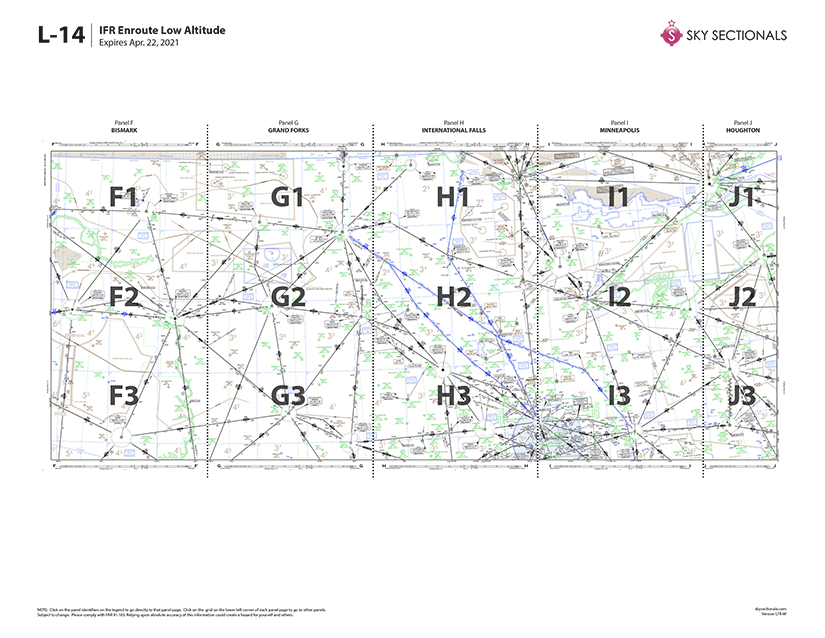
We’ve divided the same chart information provided on FAA low-altitude enroute charts into “panels” formatted for letter-sized paper that you can print yourself.
High-resolution maps calibrated for readability and fidelity on color inkjet and laser printers.
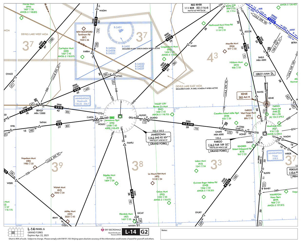
The same design and information you're used to seeing from FAA charts.
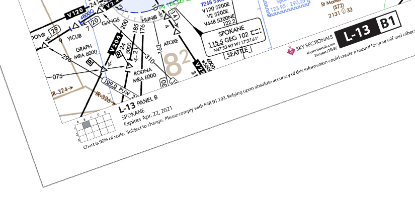
SkySectional low-altitude enroute sectional print at 90% scale to ensure readability while minimizing the total number of panels.
Generous overlap with adjoining panels makes tracking your route easy.
Information at the bottom provides chart name, grid location, and expiration at-a-glance.
Universal grid at the bottom left allows you to easily determine chart location and adjoining panels.
Notes section provides area to jot down route details or reminders.
To help you get a better idea of what SkySectional charts are like, we’ve put together a few free samples. Simply fill out the form below, and you’ll quickly get an email with the link to download our sample charts.
Easily Get Your Bearings
You’ve probably noticed that Low Enroute charts are divided into vertical panels–each with a letter and city identifier. We’ve used that same information to slice the charts in developing SkySectional Low Enroute charts and each vertical panel fits on only 3 pages. Plus, we always provide generous overlap to adjoining pages so you never “fly off” a page.
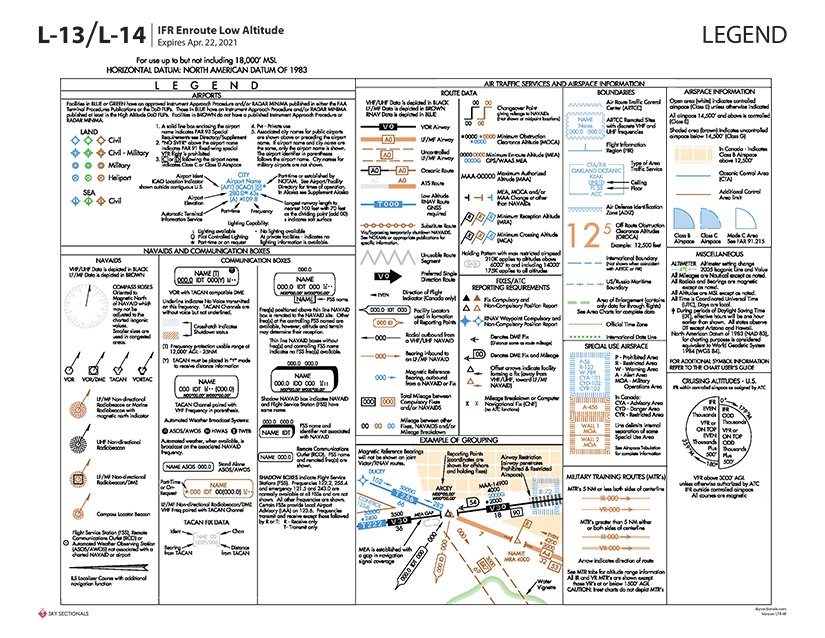
Single Page Legend
The standard legend for Low Enroute Charts takes up an incredible amount of space. We give you the exact same information, but we’ve reformatted everything to conveniently fit on a single page so everything you need can be close at hand.
MOAs, MTRs & Airport Listings...
All of the additional information included on the standard paper Enroute charts are provided. All the MTR, MOA, Special Use Airspace and Airport Listings are included. Best of all, because SkySectional Enroute Charts are sliced using the same panel grid system as paper charts, when a table tells you an airport or MOA is on a particular panel, you can just turn to those pages and find it.
Easier Navigation
You can’t make the skies easier to navigate without being able to navigate the charts. That’s why every page of a SkySectional Low Enroute chart includes information to keep your oriented. You’ll quickly find the chart (in this case, L-13), panel letter (B) and name (SPOKANE) and the grid will show you how the page is located relative to full chart.